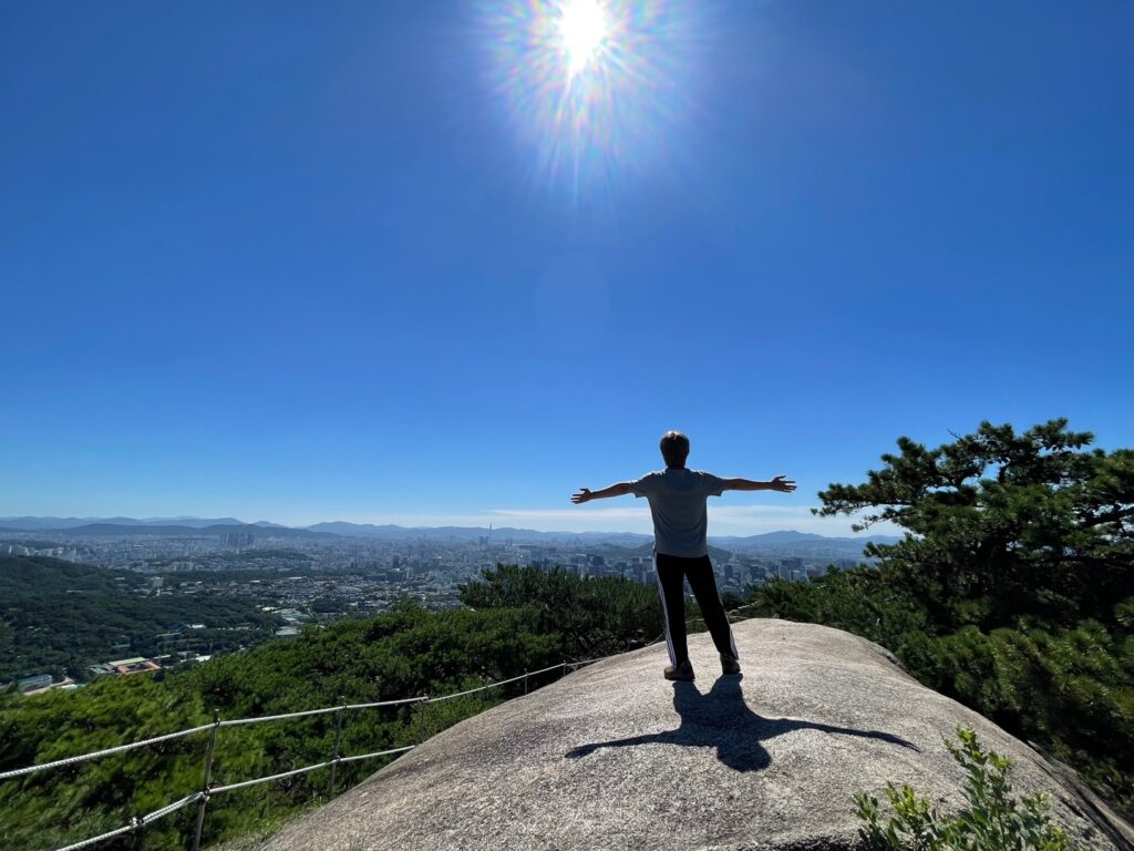
If you want to see beautiful scenery while walking in seoul?
Korea is surrounded by the sea on three sides and boasts a natural environment with dense forests covering approximately 64% of the country. This is the fourth largest forest area in the world among OECD countries, following Finland, Japan, and Sweden. In particular, Seoul, which has a high population density, also has approximately 27% of its mountainous area, providing various opportunities to enjoy nature in the city.

Hiking and trails have recently become popular among foreign tourists visiting Korea. For those who want to travel around Seoul while enjoying beautiful natural scenery and urban landscapes at the same time, the Seoul Metropolitan Government has been operating the ‘Seoul Trail’ since 2014.
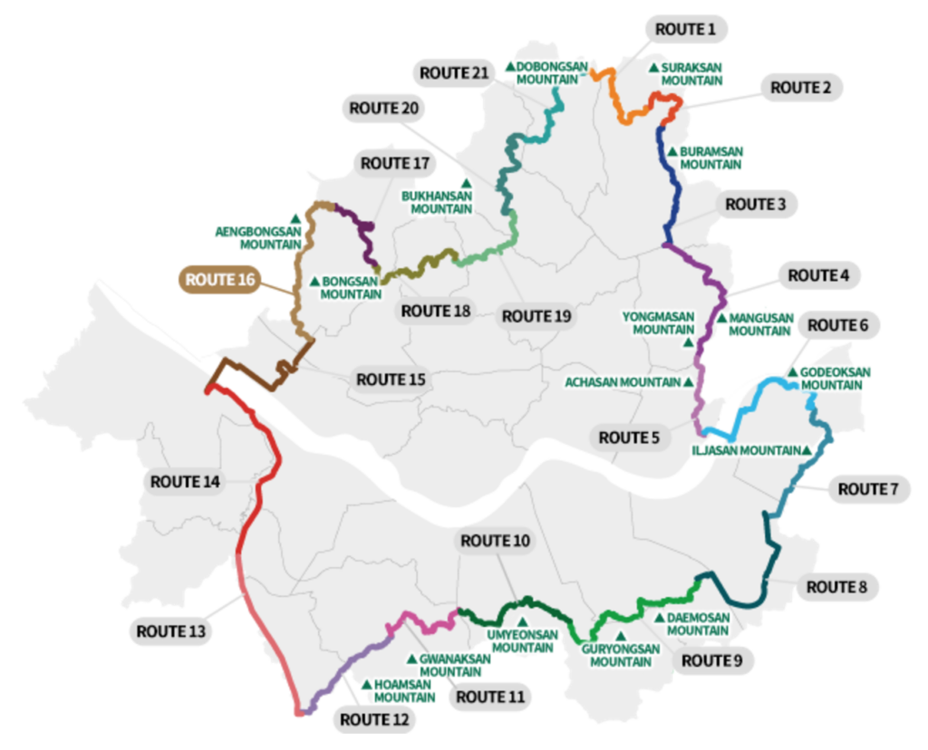
The “Seoul Trail” consists of a total of 21 courses that circle Seoul, with an average of 6 km per course and a duration of 2 to 4 hours. You can vividly experience Seoul’s history, culture, and natural ecology by walking along the 156.5 km long trail. Each course is adjacent to a subway station, making it easily accessible, and has various amenities such as rest areas, book cafes, and shelters. It is also designed to connect traditional temples and historic sites, allowing you to learn about history and culture, and relax in beautiful nature.
The “Seoul Trail” is more than just a walking course; it offers a special experience that lets you fully experience the charm of Seoul. If you want to discover the beauty of Seoul, where the city and nature are in harmony, walk the “Seoul Trail”.

Route 1. Suraksan Mountain (Difficulty: Hard)
This is a representative mountain course in Seoul, and its steep stairs and dense forest paths are impressive. The view of the city from the top of Suraksan Mountain is overwhelming.
- Major Points and Facilities
- Suraksan Mountain
- Seoul Iris Garden
- Byeogundonggyegok Valley (Surakgolgyegok Valley)
- Observation Deck
- Suamsa Temple
- Nowongol Valley (Cheon Sang-byeong Mountain Path)
- Quarry
- Nearby subway stations: Dobongsan station, Danggogae station
- Distance: 6.3 km
- Duration: 2h 50m
Route 2. Deongneung-gogae Pass (Difficulty: Hard)
This course passes through the historic Deokneung Pass, connecting Bukhansan and Suraksan. You can feel the grandeur of the Joseon royal tombs.
- Major Points and Facilities
- Suraksan Recreational Forest
- Surak Archery Range (Dongmakgol Archery Range)
- Deongneung-gogae Pass
- Small Quarry
- Nearby subway stations: Danggogae station
- Distance: 5.4 km
- Duration: 2h 50m
Route 3. Buramsan Mountain (Difficulty: Medium)
The view of downtown Seoul from the top of Bul-am Mountain is spectacular. The relatively gentle slope makes it suitable for family hikes.
- Major Points and Facilities
- Buramsan Mountain
- Big Yard
- Buramsan Mountain Royal Azalea Park
- Buramsan Elevator Observatory
- Taereung Royal Tomb
- Wide Flat Rock
- Astro Seoul
- Hakdoam Rock
- Gyeongchunseon Line Forest
- Hwarangdae Railroad Park
- Gongneung Dokkaebi Market
- Nearby subway stations: Danggogae station, Hwarangdae station
- Distance: 6.9 km
- Duration: 2h 30m
Route 4. Mangusan & Yongmasan Mountains (Difficulty: Easy)
It is a representative mountain in the northeastern part of Seoul, and is characterized by relatively gentle slopes and wide forest paths.
- Major Points and Facilities
- Mangusan Mountain
- Yongmasan Mountain
- Mangu Cemetery Park
- Joongnang Observatory
- Forts in Yongmasan Mountain
- Dongwon Market
- Sagajeong Market
- Nearby subway stations: Hwarangdae station, Sagajeong station
- Distance: 7.7 km
- Duration: 3h
Route 5. Achasan Mountain (Difficulty: Medium)
It is connected to Seoul Forest, so you can enjoy nature in the city. You can see the whole of Seoul at a glance from Achasan Beacon Mound.
- Major Points and Facilities
- Achasan Mountain
- Observation Deck
- Achasan Mountain Forts
- Sunrise Square
- Goguryeojeong Pavilion
- Achasanseong Fortress
- Achasan Mountain Forest Library
- Achasan Eoullim Garden
- Achasan Leisure Center (to be established)
- Hongryeonbong Park
- Seoul Children’s Grand Park
- Sinseong Traditional Market
- Nearby subway stations: Sagajeong station, Gwangnaru station
- Distance: 4.6 km
- Duration: 2h 10m
Route 6. Godeoksan Mountain (Difficulty: Easy)
Godeoksan Mountain, located in Gangdong-gu, has a quiet and secluded atmosphere where you can enjoy a leisurely walk.
- Major Points and Facilities
- Godeoksan Mountain
- Gwangnaru Hangang Park
- Amsa History Park
- Archaeological Site in Amsa-dong
- Amsa-dong Prehistoric Museum
- Godeoksan Walkway
- Amsa Complex Market
- Nearby subway stations: Gwangnaru station, Godeok station
- Distance: 9.3 km
- Duration: 3h
Route 7. Iljasan Mountain (Difficulty: Easy)
Iljasan Mountain, located on the border of Nowon-gu and Dobong-gu, is a low mountain that is great for a light walk.
- Major Points and Facilities
- Iljasan Mountain
- Myeongil Neighborhood Park
- Gildong Ecological Park
- Iljasan Herb Astronomy Park
- Iljasan Dungul (Dunchon’s Cave)
- Bangi-dong Ecosystem Landscape Conservation Area
- Olympic Park
- Earthen Fortification in Pungnap-dong
- Gildong Bokjori Market
- Pungnap Market
- Nearby subway stations: Godeok station, Olympic park station
- Distance: 7.7 km
- Duration: 3h 15m
Route 8. Jangjicheon & Tancheon Streams (Difficulty: Easy)
This course is built along Tancheon, and the bicycle path and walking path are well-maintained.
- Major Points and Facilities
- Jangjicheon Stream
- Tancheon Stream
- Seongnaecheon Stream
- Wirye Lake Park
- Nearby subway stations: Olympic park station, Suseo station
- Distance: 8.6 km
- Duration: 2h 35m
Route 9. Daemosan & Guryongsan Mountains (Difficulty: Easy)
This course connects Daemosan and Guryongsan, located on the southern slopes of Gwanaksan.
- Major Points and Facilities
- Daemosan Mountain
- Guryongsan Mountain
- Tanheo Memorial Museum
- Cemetery of the Prince Gwangpyeong Branch of the Jeonju Yi Clan
- Stone Tower Observatory
- Daemosan Urban Nature Park
- Bulguksa Temple
- Yeouicheon Stream
- Maeheon Yun Bong-Gil Memorial Museum
- Maeheon Citizen’s Forest (ex-Yangjae Citizen’s Forest)
- Nearby subway stations: Suseo station, Yangjae citizen’s forest station
- Distance: 10.7 km
- Duration: 4h 50m
Route 10. Umyeonsan Mountain (Difficulty: Medium)
Umyeon Mountain, located in Seocho-gu, is a place where you can view the entire city of Seoul at a glance.
- Major Points and Facilities
- Umyeonsan Mountain
- Gwanmunsa Temple
- Daeseongsa Temple
- Umyeonsan Wishing Tower
- Seoul Arts Center
- National Gugak Museum
- Nearby subway stations: Yangjae citizen’s forest station, Sadang station
- Distance: 7.6 km
- Duration: 3h 20m
Route 11. Gwanaksan Mountain (Difficulty: Medium)
This is Seoul’s representative mountain course, where rock climbing courses and lush forest paths are harmoniously combined.
- Major Points and Facilities
- Gwanaksan Mountain
- Gwaneumsa Temple
- Gwanaksan Mudanggol Observatory
- Observatory of the Patriotic Forest Path
- Nakseongdae
- Nakseongdae Park
- Inheon Market
- Nearby subway stations: Sadang station, Gwanaksan station
- Distance: 5.7 km
- Duration: 2h 30m
Route 12. Hoamsan Mountain (Difficulty: Medium)
Hoamsan Mountain, located on the southern slope of Gwanaksan Mountain, has a relatively gentle slope and is suitable for family hikes.
- Major Points and Facilities
- Hoamsan Mountain
- Gwanaksan Lake Park
- The Tomb of Yun Gil
- Samseongsan Sanctuary
- Hoapsa Temple
- Hanumul
- Hoamsanpokpo Falls
- Hoamsanseong Fortress
- Hoamsan Forest Park
- Nearby subway stations: Gwanaksan station, Seoksu station
- Distance: 7.3 km
- Duration: 3h 30m
Route 13. Anyangcheon Upstream (Difficulty: Medium)
This course was created along the upper reaches of Anyangcheon, and the bicycle path and walking path are well-maintained.
- Major Points and Facilities
- Anyangcheon Stream
- Anyangcheon Cherry Blossom Path
- Hyundai, Silkroad Market
- Byeolbit Nammun Market
- Nearby subway stations: Seoksu station, Guil station
- Distance: 8 km
- Duration: 2h 5m
Route 14. Anyangcheon Downstream (Difficulty: Easy)
This course is built along Anyangcheon Stream, and the bicycle path and walking path are well-maintained.
- Major Points and Facilities
- Gocheok Sky Dome
- Galsan Neighborhood Park
- International Seon Center
- Migratory Birds Protection Area
- Yanghwagyopokpo Falls
- Hwanggeumnae Neighborhood Park
- Heo Jun Museum
- Seoul Botanic Park
- Seounam Water Recycling Center (park planning)
- Nearby subway stations: Guil station, Gayang station
- Distance: 10.2 km
- Duration: 2h 25m
Route 15. Noeul & Haneul Parks (Difficulty: East)
- Major Points and Facilities
- Hangang Park Nanji Campground
- World Cup Park
- Noeul Park
- Noeul Park Family Campground
- Haneul Park
- Metasequoia Tree Road
- Nanjicheon Park
- Oil Tank Culture Park
- Mapo Agricultural & Fish Market
- Nearby subway stations: Gayang station, Jeungsan station
- Distance: 7.7 km
- Duration: 2h 10m
Route 16. Bongsan & Aengbongsan Mountains (Difficulty: Hard)
This course connects Bongsan and Aengbongsan, located on the northern side of Bukhansan National Park.
- Major Points and Facilities
- Bongsan Mountain
- Aengbongsan Mountain
- Colony of Sorbus Trees in Bongsan Mountain
- Bongsan Sunrise Park Observatory
- Bongsan Beacon Mound
- Suguksa Temple
- Seooreung Pass Eco-bridge
- Aengbongsan Family Campground
- Jeungsan Market
- Nearby subway stations: Jeungsan station, Gupabal station
- Distance: 9.1 km
- Duration: 4h 15m
Route 17. Bukhansan Mountain & Eunpyeong-gu (Difficulty: Medium)
This circular trail has the theme of ‘The Road that Touches the Sky’, and you can enjoy various landscapes.
- Major Points and Facilities
- Bukhansan Mountain
- Imalsan Mountain
- Eunpyeong History Hanok Museum
- Eunpyeong Hanok Village
- Rock-carved Standing Buddha at Samcheonsa Temple Site
- Jingwansa Temple
- Savina Museum
- Multiculture Museum
- Sky Observatory Skywalk
- Bukhansan Eco Park
- Eunpyeong Culture & Arts Center
- Nearby subway stations: Gupabal station, Bulgwang station
- Distance: 5.9 km
- Duration: 2h 45m
Route 18. Bukhansan Mountain & Jongno-gu (Difficulty: Medium)
With the theme of ‘A downtown road where valleys and mountains meet’, you can feel the atmosphere of a village road that is different from the existing downtown area. You can also enjoy the exhibition facilities in various places, so you can enjoy various visual pleasures.
- Major Points and Facilities
- Bukhansanseong Fortress
- Tangchundaeseong Fortress Hidden Gate
- Samseong Museum of Publishing
- Young In Museum of Literature
- Total Museum of Contemporary Art (TMCA)
- Sangwon Museum of Art
- Hwajeong Museum
- Myogaksa Temple
- Bugak Palgakjeong Pavilion
- Okcheonam Hermitage
- Sukjeongmun Gate
- Nearby subway stations: Bulgwang station, Gyeongbokgung station
- Distance: 7.4 km
- Duration: 4h
Route 19. Bukhansan Mountain & Seongbuk-gu (Difficulty: Medium)
As the theme is ‘A quiet forest path to walk in thought’, the entire course is made up of forest paths, and there is a temple in the middle of the forest path, so you can take a break and enjoy contemplating your thoughts.
- Major Points and Facilities
- Choi Man Lin Museum
- Gyeongguksa Temple
- Seongbuk Eco Experience Center
- Ppallaegol Valley
- Huingureum (White Cloud) Observatory
- Hwagyesa Temple
- Jeongneung Market
- Nearby subway stations: Gyeongbokgung station, Hwagye station
- Distance: 6 km
- Duration: 2h 50m
Route 20. Bukhansan Mountain & Gangbuk-gu (Difficulty: Medium)
As the theme is ‘A path to think about the country in front of a graveyard’, there are many relics of historical figures and some cultural and artistic figures, so you can think about Korean history and national character while walking along the forest path.
- Major Points and Facilities
- Bonwonjeongsa Temple
- Tomb of Yi Jun
- April 19th National Cemetery
- Solbat Neighborhood Park
- Doseonsa Temple
- Jangmiwon Market
- Nearby subway stations: Hwagye station, Bukhansan ui station
- Distance: 7.1 km
- Duration: 3h 30m
Route 21. Bukhansan Mountain & Dobong-gu (Difficulty: Medium)
As the theme is a road with deep historical resonance, there are many historical and cultural heritage sites scattered throughout, so there is a lot to see.
- Major Points and Facilities
- Dobongsan Mountain
- Banghak-dong Ginkgo Tree
- Tomb of Crown Prince Yeonsan
- Graveyard for Lord Yanghyo and Princess Jeongui
- Ssangdungi Observatory
- Dobongsa Temple
- Cheonchuksa Temple
- Baegun Market
- Banghak-dong Dokkaebi Market
- Nearby subway stations: Bukhansan ui station, Dobongsan station
- Distance: 7.3 km
- Duration: 3h 25m
You can also check more detailed information on the seoul trail website → Click
P.S
Originally, it was 8 courses with an average length of 23km per course, but it was divided into 21 courses after receiving many opinions.
I also completed all 8 courses when it was composed of 8 courses, but I felt that it was too difficult to be called a trail course, so I thought it could be difficult for beginners, so I also have a positive view of this course reorganization.


